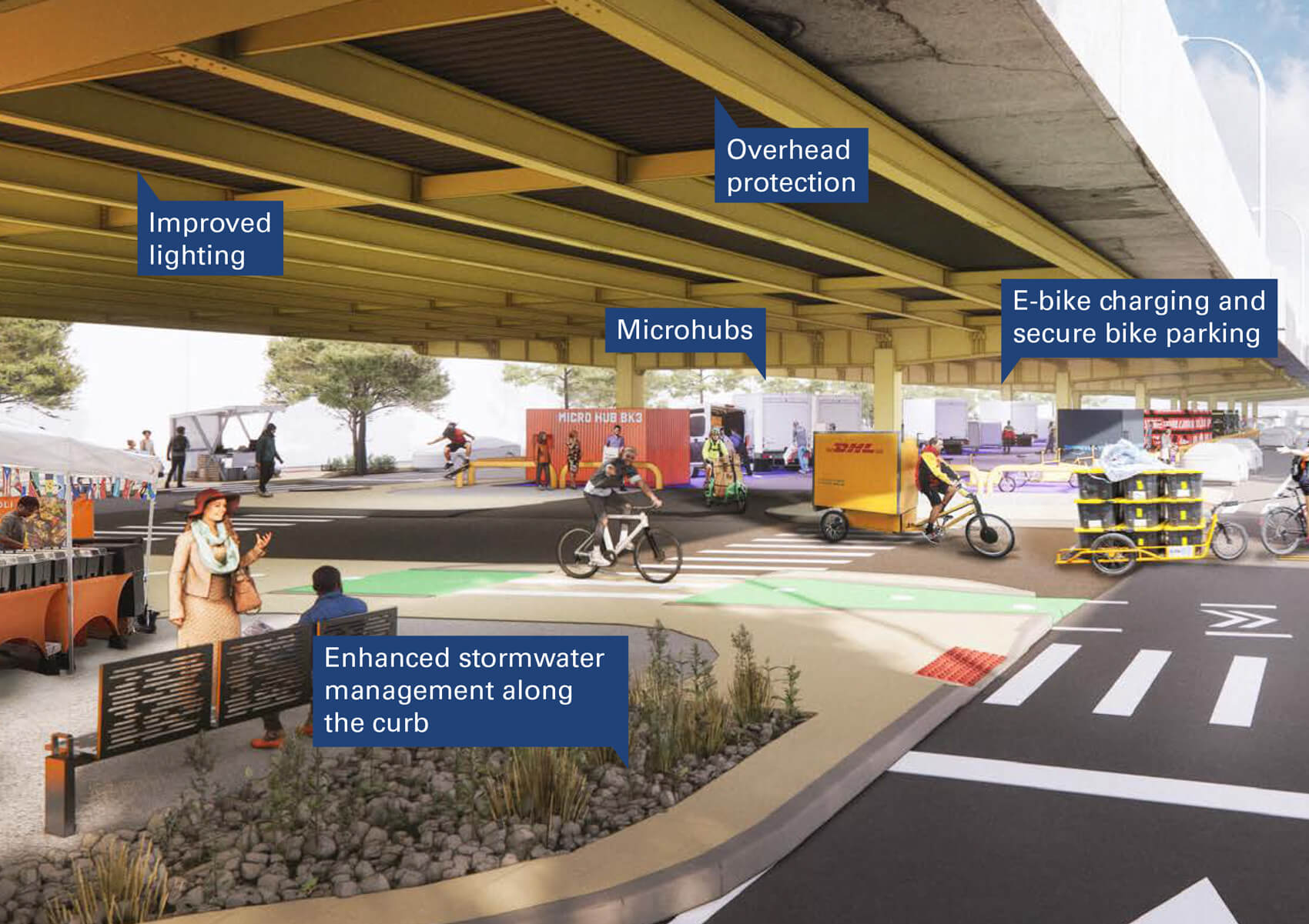
WXY released last week a new vision for streets, sidewalks, parks, and empty lots near one of New York’s most trafficked vehicle corridors, the Brooklyn-Queens Expressway (BQE). The infrastructure program was laid out in a 154-page document, BQE North & South: Safe, Sustainable, Connected.
The report contains urban design concepts for how to improve public spaces and streetscapes, redesign intersections, and repurpose swaths above and below the BQE. It entails capping sections of the BQE, not unlike visions for capping the Cross Bronx Expressway underway today, but also improving crossings for pedestrians and cyclists near its intimidating trenches and underbellies.
The master plan shepherded by the New York Department of Transportation (DOT) started in the form of working groups in 2022. It was financed by a $5.6 million federal planning grant from the Biden Administration.

The plan, WXY noted, is informed by input from a number of stakeholders in order to bolster jobs; public health; and recreational, educational and cultural opportunities. It’s also plugged into Vision Zero, a program for reducing traffic deaths and injuries.
Urban Surgery
The BQE, a Robert Moses project finished in 1964, slices and dices neighborhoods all the way from Red Hook, Brooklyn to Newtown Creek—a 12-mile stretch. Its disastrous consequences for Brooklyn’s 2nd Avenue were historicized in Robert Caro’s The Power Broker, and later Segregation by Design. The plan by WXY is to essentially make these places better and reduce the BQE’s detrimental environmental and social impact.
Today, working with the BQE is tricky because 150,000 motor vehicles use it every day. Furthermore, parts of it are owned by the state of New York, and others by the city of New York. Anyone who’s worked in New York long enough will tell you that juggling between city and state agencies is not any easy task, to put it lightly.

BQE North connotes the sliver between Sands Street and the Kosciuszko Bridge, which is state-owned. The part between Sands Street and Atlantic Avenue (BQE Central) is city-owned. And the area between Atlantic Avenue and the Verrazzano Bridge (BQE South) is state-owned. Overall, the master plan posits seven proposals for improving the pedestrian and cycling journey between BQE North, BQE Central, and BQE South.

Seven Ideas for Making the BQE Better
What exactly do the architects and urban planners have in mind? First, WXY envisions active uses like pop-up markets underneath the Meeker Avenue section of BQE North. Second, the plan would deliver a cap above the Marcy Green section to reduce pollution. It would also cap over McKinley Park and Union and Sackett Streets in Brooklyn Heights.

Where capping isn’t possible or necessary, the master plan calls for significant street improvements for pedestrians and cyclists. Crossings near the trenches would be improved at Park Avenue, near the Brooklyn Navy Yard, at Clinton and West 9th Streets in South Slope, and at 3rd Avenue in Gowanus.

“We’re not the first administration to embark on fixing the BQE … but we must be the last,” said Meera Joshi, Deputy Mayor of Operations, in a statement. “We will get shovels in the ground. When we do, one long chapter will end, and a new one will begin: a connected BQE.”
New York Department of Transportation (DOT), WSP, and 3 x 3 authored the report with WXY. Arab Association of America, Transportation Alternatives (TA), Brooklyn-Chinese American Association, El Puente, United Jewish Organization of Williamsburg, and other community organizations cultivated the plan in more than 400 working sessions over two years.

